Gillies Ave. recently became part of my daily cycle commute, and I am concerned about the safety on this street.
Today
It is a heavily used street by school students of all ages, and yet there are many hazards:
- Moving traffic is directly next to the footpath in many places, without any buffer such as a berm or parked cars.
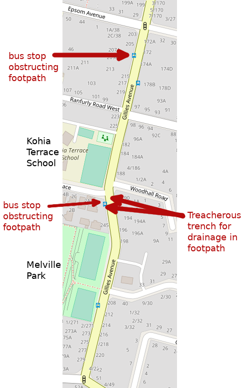
- Footpaths are narrow in many places, either due to property line and kerbside being very close, or due to permanent obstructions such as bus shelters or poles.
- Footpaths are often heavily obstructed, including significant foliage overgrowth, rubbish bin collections on Tuesdays, poorly mowed berms, or occasionally vehicles.
- Footpaths are uneven and treacherous in many places, due to wear and tear, or one area with an intentional permanent drainage trench.
- North-bound rush hour traffic is intense on this street and there are no traffic-calming measures in place.
- Several commercial driveways in use during school travel hours.
For cycling in particular Gillies Ave. poses many difficulties:
- Significant parts of Gillies Ave are marked for two lanes of road traffic, and the traffic density makes cycling on the street intimidating in those portions, not only for school students but for other commuters as well.
- The footpath has all of the immovable hazards mentioned earlier, but in addition there are many pedestrians.
- The adjacent north-south main thoroughfares are Mt Eden Road and Manukau Road which are even more intimidating with the partial bus lane and the T3 lane.
- The resulting behaviour for cyclists on Gillies Ave is to weave off and on the road, which often appears unpredictable to motorists, creating more risk of accident.
However, there is significant potential in the street to create something better:
- Gillies Ave is very wide, and there is plenty of space to make adjustments.
- It is only the north-bound traffic which is heavy, the south-bound traffic is much lighter, even in morning and evening rush hours, and the two lane sections are not heavily used.
- Even where parking is available on Gillies Ave, it is rarely occupied.
- The traffic flow requirements are quite simple, the majority of people are merely trying to get onto the motorway, or get their children to school safely.
The Future
Gillies Ave. could become a fantastic transport corridor for school students, both walking and cycling. Currently many students from several local schools already use it: Epsom Girls Grammar, Auckland Grammar, Kohia Terrace, Auckland Normal Intermediate, and Epsom Normal. If it became a safe and comfortable transport corridor, it would surely attract students from other local schools, including St. Cuthbert’s College, Diocesan, Dilworth, and Newmarket Primary. The combined roll of these schools probably numbers over 10,000 students.
Fortunately, the space is there to make this happen:
- For most of Gillies Ave south of Epsom Ave the lanes are very wide, and space could be reclaimed by repainting alone.
- The very under-utilised on-street parking can be removed to provide space.
- Extra-wide berms in many places can be repurposed.
- Between the motorway and Epsom Ave south-bound traffic is light, so reducing to one lane would have minimal impact.
Detailed Map
The following maps of Gillies Ave. identify some specific features, both issues and opportunities for improvement. I will expand this information with photos of specific features to illustrate the hazards, including foliage and rubbish bins.
Gillies Ave North
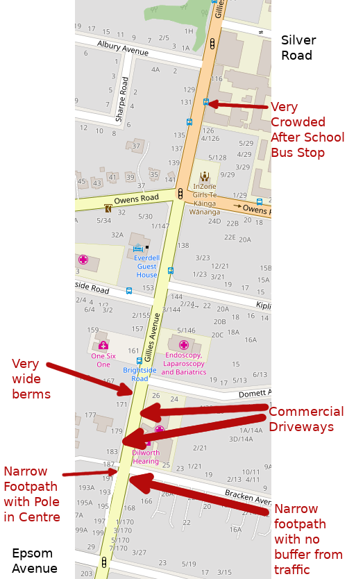
Gillies Ave South